This week we will complete the final chapter of Irish born Canadian geographer and explorer Captain John Palliser. After his stint in the military service of his homeland, Palliser embarked on numerous adventures into the wilderness of Canada, completing maps and diaries full of information on the flora, fauna and topography of the hundreds of miles of landscape that his expedition visited.
In 1863, in the latter part of his colourful career, he explored the rugged area from Fort Edmonton to Mountain House (now Rocky Mountain House); tracing some of the footsteps of the legendary explorer David Thompson.
Captain Palliser’s mid-winter trip took him into the relatively uninhabited areas west of Ponoka, the first two days of which we covered his overwhelming observations last week, and will now follow his final two days before he headed towards the mountains.
January 11, 1863: This morning, keeping a little more to the west, our course hitherto having been SSW, we soon reached a range of hills, over which we had to pass. We entered them along a very abrupt gully, in which runs Weed Creek, called after the smoking weed, which is found in great abundance here. Here I again observed the pine, with cones similar to those, which I had observed at the Carlton Horse Guard. It seemed very plentiful wherever there was loose gravel soil on the ridges. Entering a narrow trail cut through very dense poplar woods, we continued for some hours passing over these hills, till at last by a rapid descent we emerged in a swampy tract of country, bordering a stream, where we halted for dinner.
At noon the thermometer stood at minus 16 degrees, but there was little or no wind now, so it did not feel so keen. Keeping for a few miles to the east of south we crossed Pigeon Creek just where it enters the valley of the Battle River. This river, which flows into the Saskatchewan at the Eagle Hills, takes its rise in great swamps and lakes, which lie to the northwest of this place. Its valley here is about 1.5 miles wide, but only 100 feet deep. From the willow-covered flats through which the stream winds with a very tortuous course, numerous lagoons show that it must frequently have changed its course, and yet it seems very sluggish. It is about 40 feet wide, and the immediate banks are 20 feet high. We crossed this valley very obliquely, and camped at sunset on its western side. The thermometer at sunset was minus 17 degrees, and to protect us from the cold wind this evening we made a shelter of poles, on which we stretched our sled wrappers. I took a meridian altitude of Jupiter at this place, and found the latitude to be 52 degrees-41 N. having traveled by the trail 70 miles from Edmonton.
January 12: We soon came to Beaver River this morning, a stream similar to Battle River, which it joins a few miles below where we crossed it. We then crossed a wooded ridge, and passed to the south of Prince Lake, which also sends a creek to Battle River, and entered on a track of high broken country, from which the timber seems to have been burnt. As we broke one of the sleds, we halted for dinner while it was being mended. Descending from the high ground we came to Gull Lake, which seemed to be a great length to the south, but we merely crossed over its northern extremity. We had now entered the river system of the South Saskatchewan, as the stream from Gull Lake flows into the Red Deer River. After crossing the lake we again ascended rapidly, and at dark encamped beside the enormous root of an upturned tree, making the best winter camp I have seen, having plenty of large timber for our fire and lots of pine bush to sleep on. I have observed today on crossing all the ridges, which generally run north and south, that while the eastern side is clothed with spruce, their west slope is clothed exclusively with poplar, and that the vegetation has much more variety on the western side. Also, I remarked the number of pendent wasp’s nests in the west slope, all of which facts must be connected with the prevalent winds modifying the general climate.
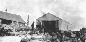
Roughly 20 years later the Dominion Land Surveyors covered this part of the country, the strong influx of settlers from all areas began to converge on the lush and fertile area to file their land claims, establish their new homes and endeavour to scratch a living out of the soil. Nearby many towns and villages began to emerge and the bountiful stands of trees were carefully harvested and floated by the thousands down the Pigeon Creek and Battle River to the sawmills in Ponoka. The lumber was used to build the future homes and businesses of Alberta, and although not all his recommendations were heeded, Captain John Palliser’s diaries and observations helped to lead the way from those humble beginnings of our proud heritage.