Subtropical Storm Alberto gained the early jump on the 2018 hurricane season as it headed toward anticipated landfall sometime Monday on the northern Gulf Coast, where white sandy beaches emptied of their usual Memorial Day crowds.
Though the Atlantic hurricane season doesn’t officially start until Friday, Alberto has become the first named storm this year, throwing disarray into long holiday weekend plans up and down Florida’s Gulf Coast. And just as Memorial Day marked summer’s unofficial start in the U.S., Alberto gave it the unofficial start of what forecasters recently predicted would be an active hurricane season.
The National Hurricane Center in Miami said at 8 a.m. EDT Monday that Alberto was maintaining its strength as it approached the Florida panhandle and was centred about 100 miles (165 kilometres) south-southeast of Destin. The storm that was expected to make landfall later Monday had maximum sustained winds of 65 mph (100 kph) and was moving north at 6 mph (9 kph).
“On the forecast track, the centre of Alberto will move over the northern Gulf of Mexico overnight and cross the northern Gulf Coast in the warning area on Monday,” the National Hurricane Center said. It warned of life-threatening surf conditions, the possibility of a few brief tornadoes in much of Florida and parts of Georgia, South Carolina and Alabama. And, it said, heavy rains are also expected in many areas.
Related: As Hurricane Irma spins, Cuba evacuates
Related: Horses ride out hurricane Irma in family’s living room
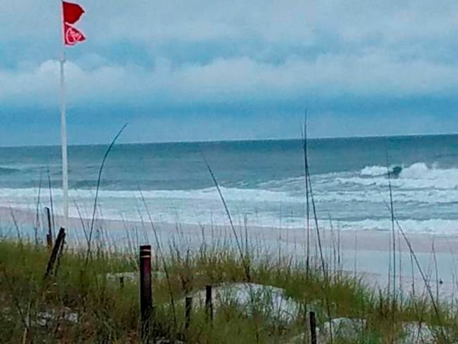
Lifeguards posted red flags along the white sands of Pensacola Beach, where swimming and wading were banned amid high surf and dangerous conditions. Gusty showers were to begin lashing parts of Florida on Sunday, and authorities were warning of the possibility of flash flooding. The hurricane centre said a tropical storm warning was in effect from the Suwannee River in Florida to the Mississippi-Alabama state line.
The storm’s approach also triggered mandatory evacuations of some small, sparsely populated Gulf Coast barrier islands in one Florida county. The Florida Division of Emergency Management said in a statement Sunday that a mandatory evacuation has been issued in Franklin County for all barrier islands there and those in the county living directly on the coast in mobile homes or in recreation vehicle parks.
A subtropical storm like Alberto has a less defined and cooler centre than a tropical storm, and its strongest winds are found farther from its centre. Subtropical storms can develop into tropical storms, which in turn can strengthen into hurricanes. Forecasters cautioned that heavy rain and tropical storm conditions could reach the northern Gulf Coast well ahead of the centre of Alberto making landfall.
The storm prompted Florida, Alabama and Mississippi to launch emergency preparations over the weekend amid expectations Alberto would reach land sometime Monday. Rough conditions were expected to roil the seas off the eastern and northern Gulf Coast region through Tuesday.
Mark Bowen, the Bay County Emergency management director, said at a Sunday afternoon news conference that the concern isn’t with storm surge due to the timing of landfall and the tides. He said Alberto’s biggest threat will be its heavy rains, with forecasts of anywhere from four to 12 inches (10-30 centimetres) of rain in some areas.
In Taylor County, there were voluntary evacuations for those in coastal zones and beach communities, mobile homes, RV parks and low-lying areas. In Gulf County, T. H. Stone Memorial St. Joseph Peninsula State Park began evacuations Sunday morning.
In Miami, organizers called off the sea portion of the Miami Beach Air & Sea Show on Sunday because of heavy rain and rough waters. And in the Tampa Bay area on the central Gulf Coast, cities offered sandbags for homeowners worried about floods.
The National Oceanic and Atmospheric Administration released a hurricane season forecast Thursday that calls for 10 to 16 named storms, with five to nine hurricanes. One to four hurricanes could be “major” with sustained winds of at least 111 mph (178 kph).
If that forecast holds, it would make for a near-normal or above-normal season. An average hurricane season produces 12 named storms, of which six become hurricanes, including three major hurricanes.
“There are no strong climate signals saying it’s going to be extremely active, like last year, or extremely weak,” said Gerry Bell, the lead hurricane forecaster at NOAA’s Climate Prediction Center, speaker with reporters Thursday.
___
AP writer Rebecca Santana reported from New Orleans.
Tamara Lush And Rebecca Santana, The Associated Press