By CHARLES TWEED
The second draft of the Battle River residential acreage study ordered by Ponoka County was presented to council Jan. 18.
Prepared by West Central Planning Agency, the study takes into account the county’s Municipal Development Plan (MDP) to concentrate most multi-lot subdivisions in a few well-defined areas, leaving the rest of the county for agricultural use.
“We want to keep the emphasis on agriculture. It’s agriculture first, but if the population explodes in the next 20 years like it did in the previous 20, these people are going to need a place to live,” said Coun. Gawney Hinkley.
The MDP shows a number of areas where council is willing to consider at residential subdivisions because the areas are accessible by good roads, have poor soils and will have less impact on farming than other areas.
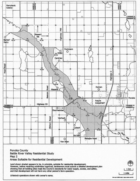
The study area looked at all quarter sections between Ferrybank Bridge and Highway 2 that have a view of the Battle River valley and an area of poorer soil between Matejka Road and Highway 53.
The study first took into account the rules set by government, which might limit development in the area. Research showed no sour gas wells in the area, no sewer lagoons within the 300-metre limit set out by government, no active or closed waste disposal sites, and the take-off and approach paths to Ponoka airport would not pass overhead.
A number of wells, pipelines and battery sites did turn up in the area and will need to be identified on any subdivision application in the future, so adequate setbacks are built into the design —residences are not allowed within 100 metres of a sweet oil or gas well, or within the right of way of a sweet oil or gas pipeline.
The area also has several abandoned wells in the area.
The Energy Resources Conservation Board said the wells don’t present any hazard but an area 10 metres square should be left undeveloped around them to allow access by service rigs, if any work needs to be done in the future.
There was an issue about proximity to highways in the area as well. Municipalities must not approve subdivision within 800 metres of a provincial highway without approval of Alberta Transportation; and parts of the area are within that range of Highway 52, 53 and Secondary Highway 795.
Livestock and elk pastures may also pose a problem as the Agricultural Operations Practices Act does not allow confined feeding operations close to residences and elk in one area would need to be protected from disturbance.
The study then began systematically eliminating land with good soil or where a crop is in, but did include some sites with good soil if they had a view of the river valley. It also eliminated land with large gravel deposits, as it may be better suited for industry down the road.
The report then focused in on which areas of the county would be best suited for residential expansion.
Development north of Highway 53 suggested a single or double row of lots with building sites on high land overlooking the Battle River valley.
The valley wall was the main concern in the study as there is a 35 per cent slope, so building would have to be a safe distance back from the top of the valley.
Development south of Highway 53 suggested several quarter sections were suitable for residential subdivisions with a pattern similar to the Morningside area where there are up to 48 lots per quarter section.
Roads and water supply were two other issues that the study looked at.
Some of the potential development sites have no road access at present and in many cases existing roads would need to be upgraded to deal with an increase in traffic flow.
Water supply was less of an issue due to a variety of issues.
Firstly, the linear style of development proposed north of Highway 53 doesn’t extract large volumes of groundwater from any one-quarter section but instead is spread out over a large area. Secondly, the clustered style proposed south of Highway 53 covers only about three sections of land and is an area where historically there has been no shortage of water. And thirdly, more groundwater is now available in Ponoka since the town has abandoned its wells, and now gets its water from a regional pipeline.
“A major issue is water and that’s what we are trying to do, is have some protection over groundwater, now and into the future. It’s something we should have in place,” said Hinkley.
The council agreed to hold an open house on the study so people could ask questions, request changes or express their opinions on the document before it is adopted as policy.
The open house date hasn’t been set, but will be advertised locally once a date is picked.